The History List
Boston Under Siege: Henry Pelham's Boston 1775-1776 colored aquatint map in an archival, full-sized print
Boston Under Siege: Henry Pelham's Boston 1775-1776 colored aquatint map in an archival, full-sized print
Couldn't load pickup availability
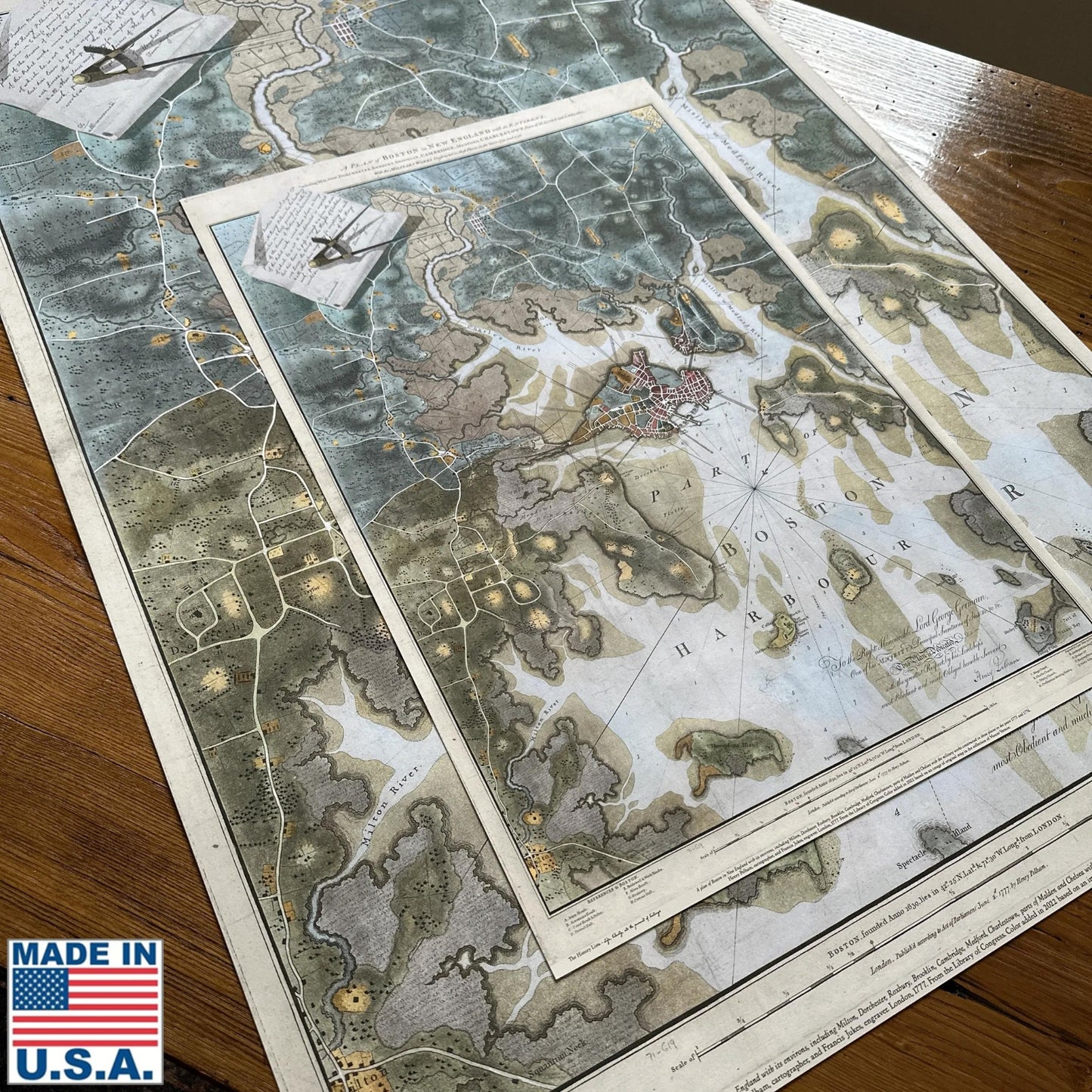
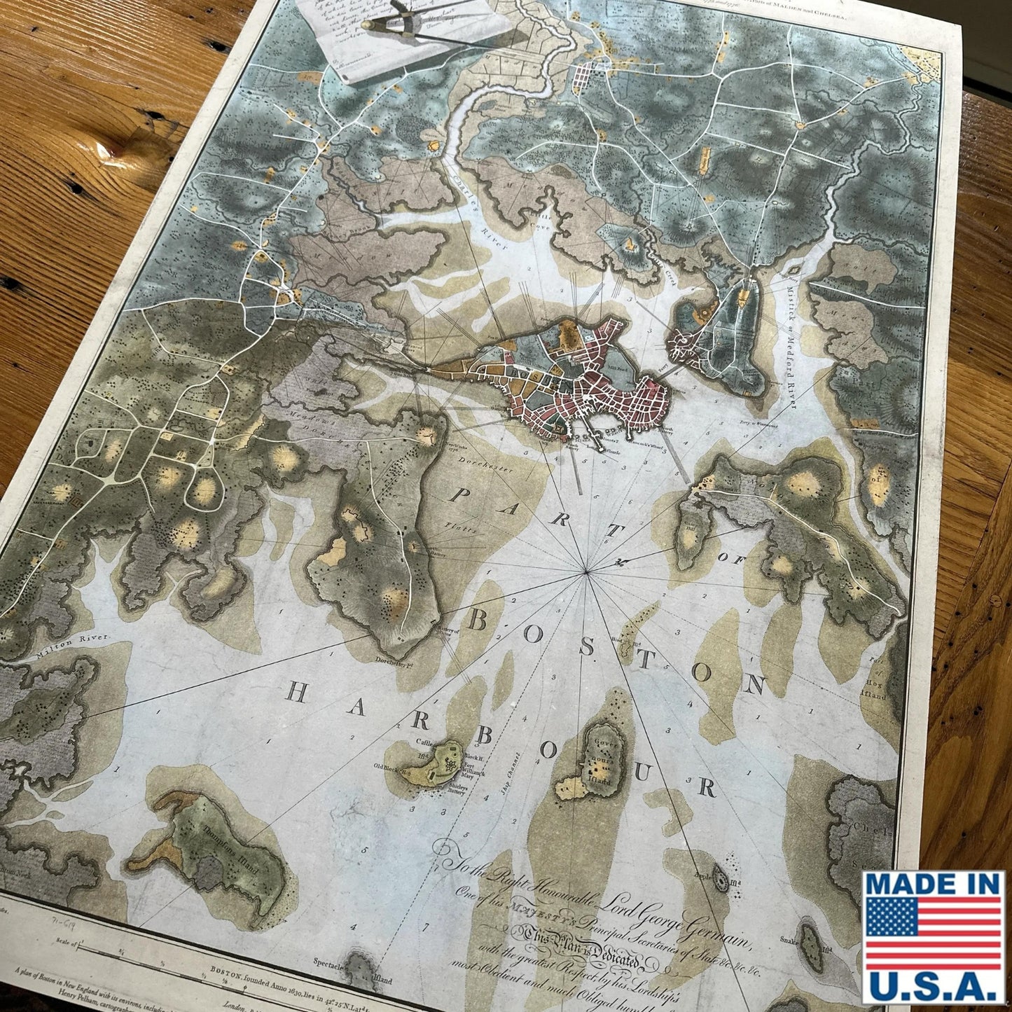
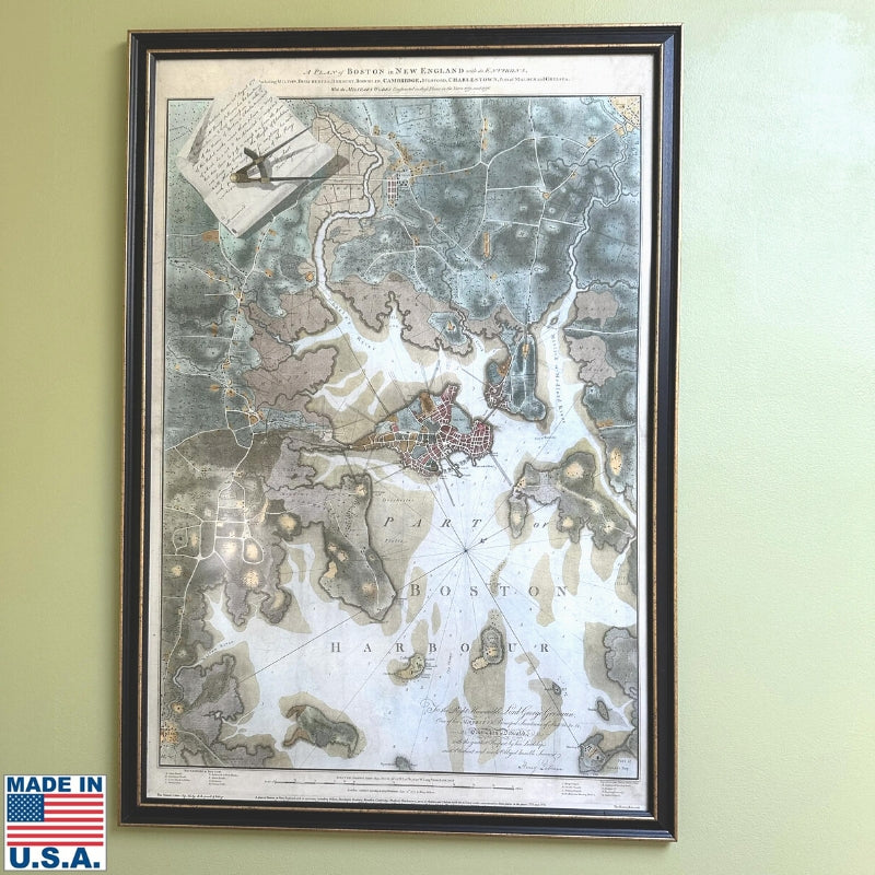
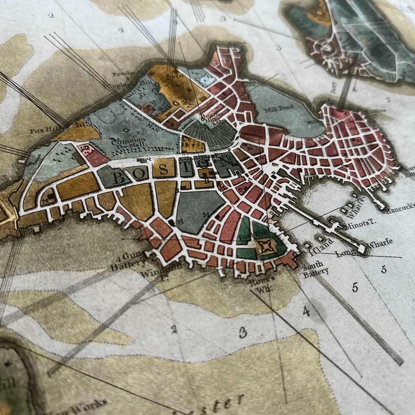
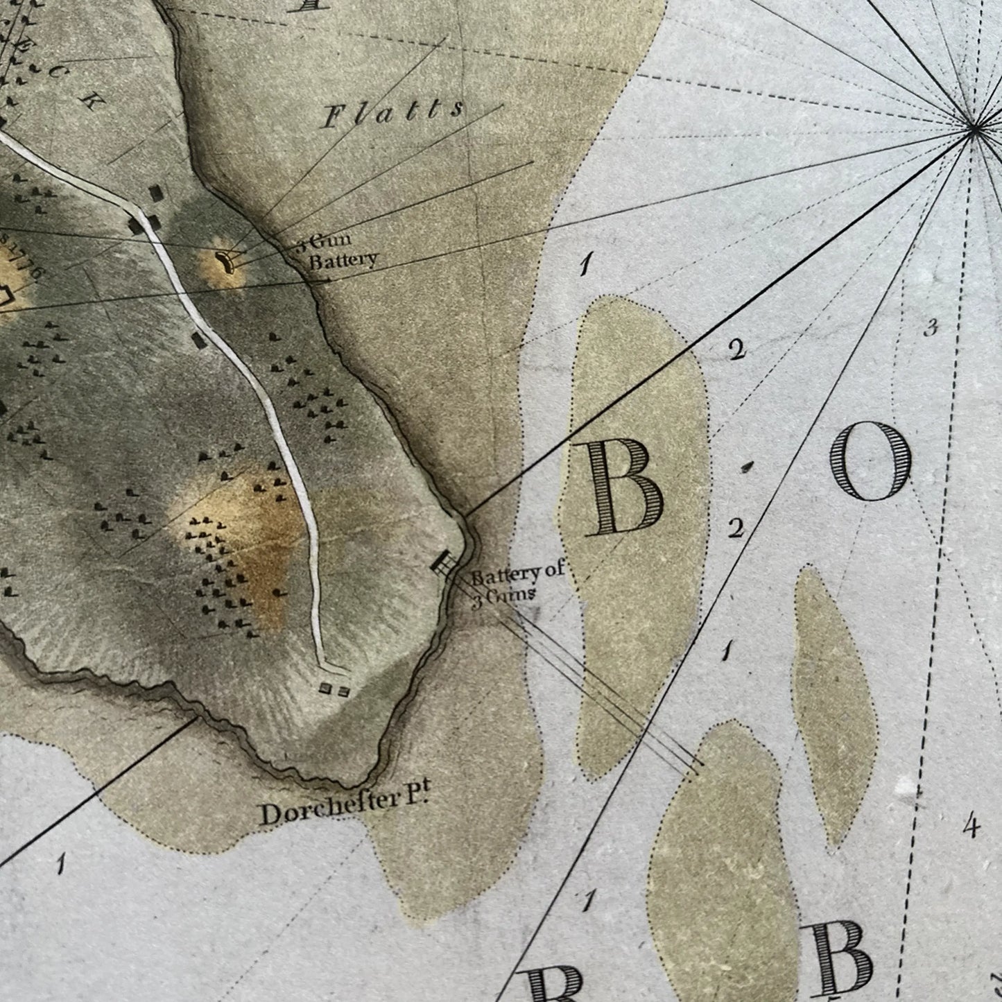
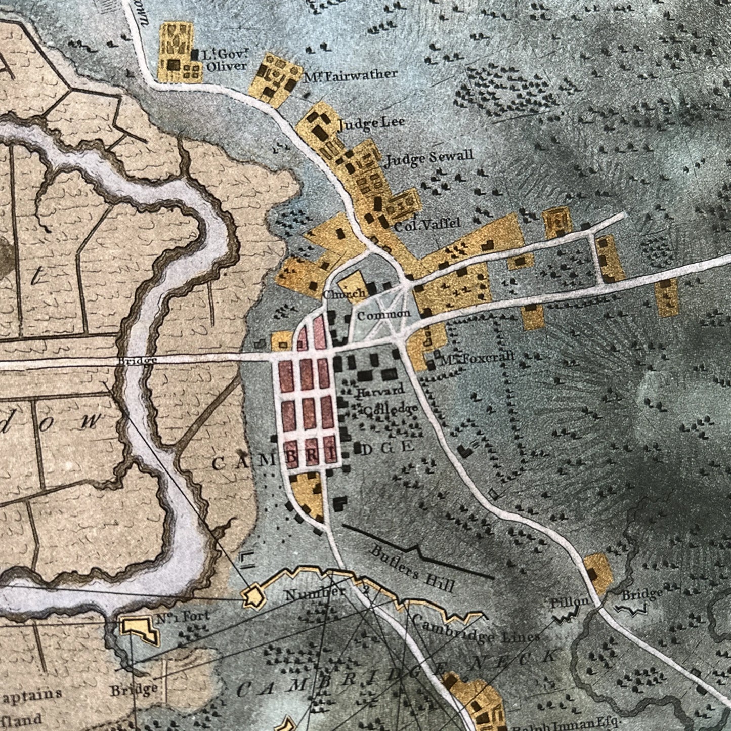
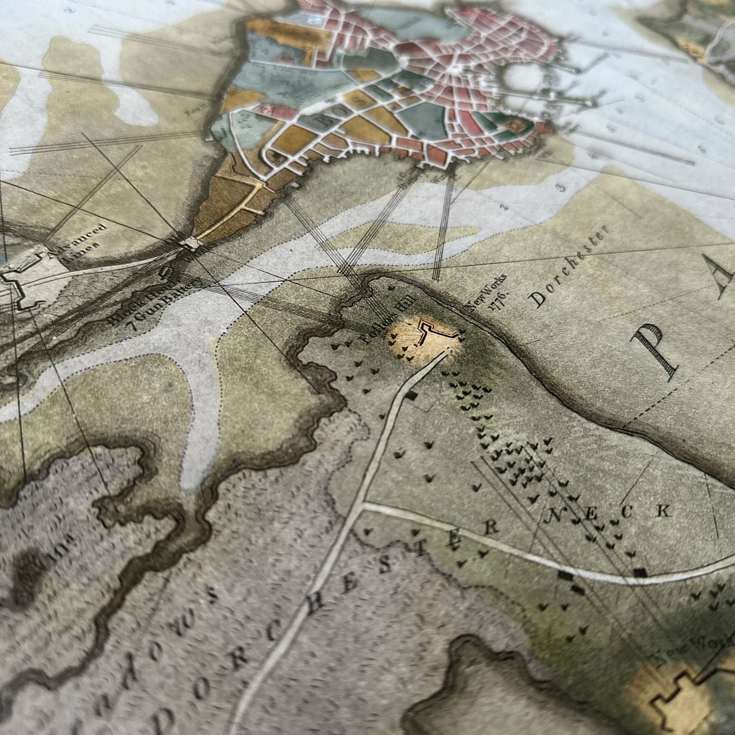
"A Plan of Boston in New England with its Environs, Including Milton, Dorchester, Roxbury, Brooklin[e], Cambridge, Medford, Charlestown, Parts of Malden, and Chelsea. With the Military Works Constructed in those Places in the Years 1775. And 1776."
Considered "the most desirable printed map of the Revolution in New England" by a dealer in rare maps, Henry Pelham's colored aquatint map of Boston under siege (1775 - 1776) is available for the first time as an archival print at 100% of the original size of 41" x 27.5".
"I was lucky enough to secure a copy of this print and have not been able to stop pouring over it. I am continuously amazed by its detail, complexity, and quality. I find myself examining the gun lines of both British and Continental artillery, especially from Charlestown as this map was drawn after the Battle of Bunker Hill. I consider myself truly fortunate to be able to have a copy of this rare map with its incredible back story. If you consider yourself interested on not just Colonial or Revolutionary history but American history, I can't recommend owning a copy of this map enough."
— Brendan M. ★★★★★
Video tour
Author J. L. Bell and I spent a day going to sites in and around Boston that played a critical role in the siege of Boston and use Henry Pelham's 1775 - 1776 map of the Siege of Boston to show their strategic importance. The video begins at Boston Neck.
The map is extraordinarily detailed, including the names of geographic locations and buildings, and showing gun emplacements and lines of fire.
We are also offering a smaller version at 24" x 16" framed or unframed.
Sizes and framing options:
- 41"x 27.5" — 100% of the size of the original. Available unframed only.
- 24" x 16" — Available framed and unframed
Printed by a fine art printer here in the United States using archival inks and heavyweight cotton rag, acid-free archival paper (230 gsm).
Frame choices for the smaller print: Frames are solid wood and made in America. Please allow up to two weeks for delivery.
Glazing: We use a museum-grade, non-glare acrylic that offers UV-protection.
Notes on the framed prints: We do not frame these with a mat. It seems more authentic without a mat. Use a microfiber cloth or similar to remove dust and fingerprints. Do not use household cleaners on the frame or on the acrylic.
Return policy on these prints: These prints and framed prints can not be returned unless there is a defect due to workmanship.
Shipping for framed prints: $20 for the 16" x 24" framed print. (The free shipping offer for purchases of $75 and above applies to regular shipping and not to items such as framed prints.)
Historical background
Henry Pelham (1749-1806) was a loyalist, the son of artist Peter Pelham and the half-brother of painter John Singleton Copley.
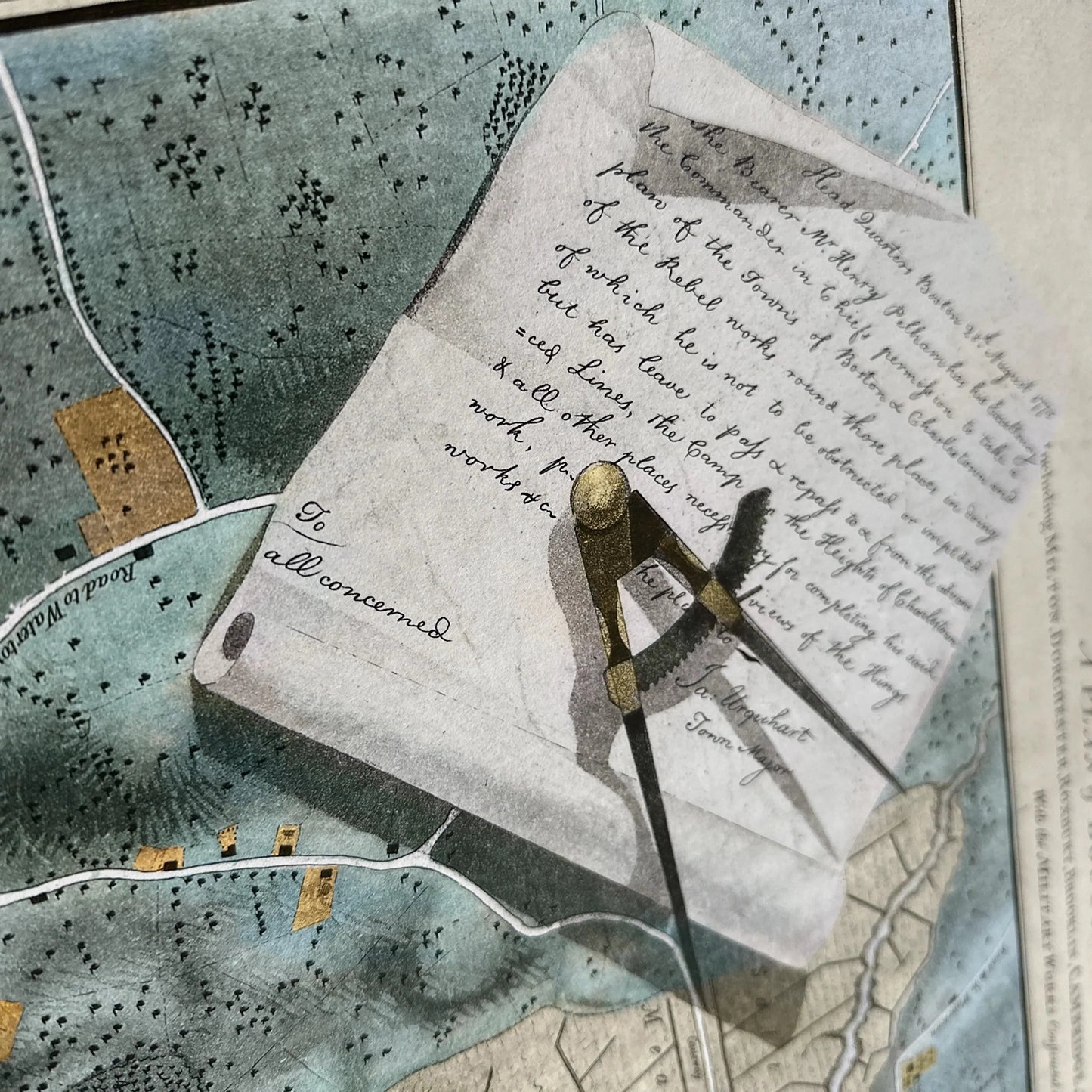
He described his project, which was commissioned by British intelligence, in a July 23, 1775 letter to Susanna Copley this way:
“. . . I have begun a survey of Charlestown, for which I have permission from Gen’l Gage and Gen’l Howe, who were polite eno to grant me a general Pass directed to all Officers commanding Guards for going to and returning from Charlestown. Gen’l How[e], to assist me in the labori[o]us part of Measuring, has kindly put a Sarjant and his Men under my Comm[an]d. This plan when finished will give a good Idea of the late battle and I propose sending Home a Coppy to be engraved, together with a View of it as it appears in its present Ruins, with the encampment on the Hills behind it.”
He wrote to his half-brother on January 27, 1776 that the survey, which extended four miles in all directions from the center of Boston, was nearly complete, and he then described the countryside he encountered:
“I don’t think if I had Liberty I could find the way to Cambridge, tho I am so well acqua[i]nted with the Road. not a Hillock 6 feet High but What is entrench’d, not a pass where a man could go but what is defended by Cannon; fences pulled down, houses removed, Woods grubbed up, Fields cut into trenches and molded into Ramparts, are but a part of the Changes the country has gone thro.
"Nor has Boston been free from the Effects of War. An hundred places you might be brought to and you not know where you were. I doubt if you would know the town at all. Charlestown I am sure you would not. They're not a Tree, not an house, not even so much as a stick of wood as large as your hand remains. The very Hills seem to have altered ther form. In Boston almost all the fences: a great Number of wooden Houses, perhaps 150, have been pull’d down to serve for fewel. Dr. Byles’, Dr. Cooper’s, Dr. Ma[t]hew’s Meeting Houses turned into Barracks. Dr. Sewells’ into a Riding School, Fanuel Hall into a Theatre. The old North pulled down and burnt. Every rising fortified.”
Henry Pelham
If Pelham's name sounds familiar it may be because you know it from his drawing of the Boston Massacre that he loaned to Paul Revere, who then copied it (with a few changes) and printed it. It's Revere's, not Pelham's original, that is the one that's widely known today.
The aquatint process
As explained by Boston Rare Maps:
"While much credit is due to Pelham’s artistry, the map’s visual appeal is greatly enhanced by Jukes’ use of the aquatint process. For this technique, the plate is covered with a granular ground or resin and 'bitten' with acid as in an etching. The image is produced by protecting certain areas of the plate from the acid with an impervious varnish, by multiple bitings to produce different degrees of darkness, and by the use of several different resins with different grains.
"The method permitted Jukes an immense range of tonal variation, which contrasts pleasingly with the line-engraved elements and imparts to the map an unusual degree of texture and depth."
Originals are extremely rare
While ours is a print of an original, to give you an idea of how rare originals are and how they are highly prized, a map (without the color) sold in 2020 at Christie's for $300,000. It was the first complete copy to appear at auction in 25 years. There are fewer than a dozen prints recorded.
Sources: Boston Rare Maps, the Paul Revere House, Christie's
Shipping
Shipping
Free standard domestic shipping on orders of $75 or more
Just add items to your cart totaling $75 or more (before tax and after discounts), and the shipping fee will be removed. No discount code needed.
This applies to most items, including shirts, caps, sweatshirts, unframed prints and posters, bracelets, lapel pins, pendants, blankets, and other qualifying items.
For orders below $75
Flat-rate shipping: Regardless of the number of items you order, the shipping price for shirts, caps, unframed prints and posters, bracelets, lapel pins, pendants, and button packs is $5.95.
For hooded and crewneck sweatshirts, mugs, and blankets, the shipping cost is $8.95.
Our flat rate shipping means you can add two or more t-shirts, sweatshirts, or caps for no additional shipping charge.
Learn more about shipping here.
All original designs are copyrighted by The History List
All original designs are copyrighted by The History List
All designs are copyrighted by The History List and the History Nerd text and design on t-shirts is a registered trademark. If you see a knock off, please let me know.
Made by America
Made by America
Almost all of the new products we offer are designed by us and made in America and most of our Rare Finds were made in America.
Our original designs are based on our nation’s history and our love of American history. Read more about other things we've created, including The History List, History Camp, and The Pursuit of History, in addition to The History List Store.
All original designs are copyrighted by The History List.
Every product that is made in America states that in the product description and includes the "Made in U.S.A." graphic. There are a relatively small number of items where we’ve not been able to find a manufacturing partner here in the States, but we continue to look.
Our nation’s history—Our original designs