

The History List
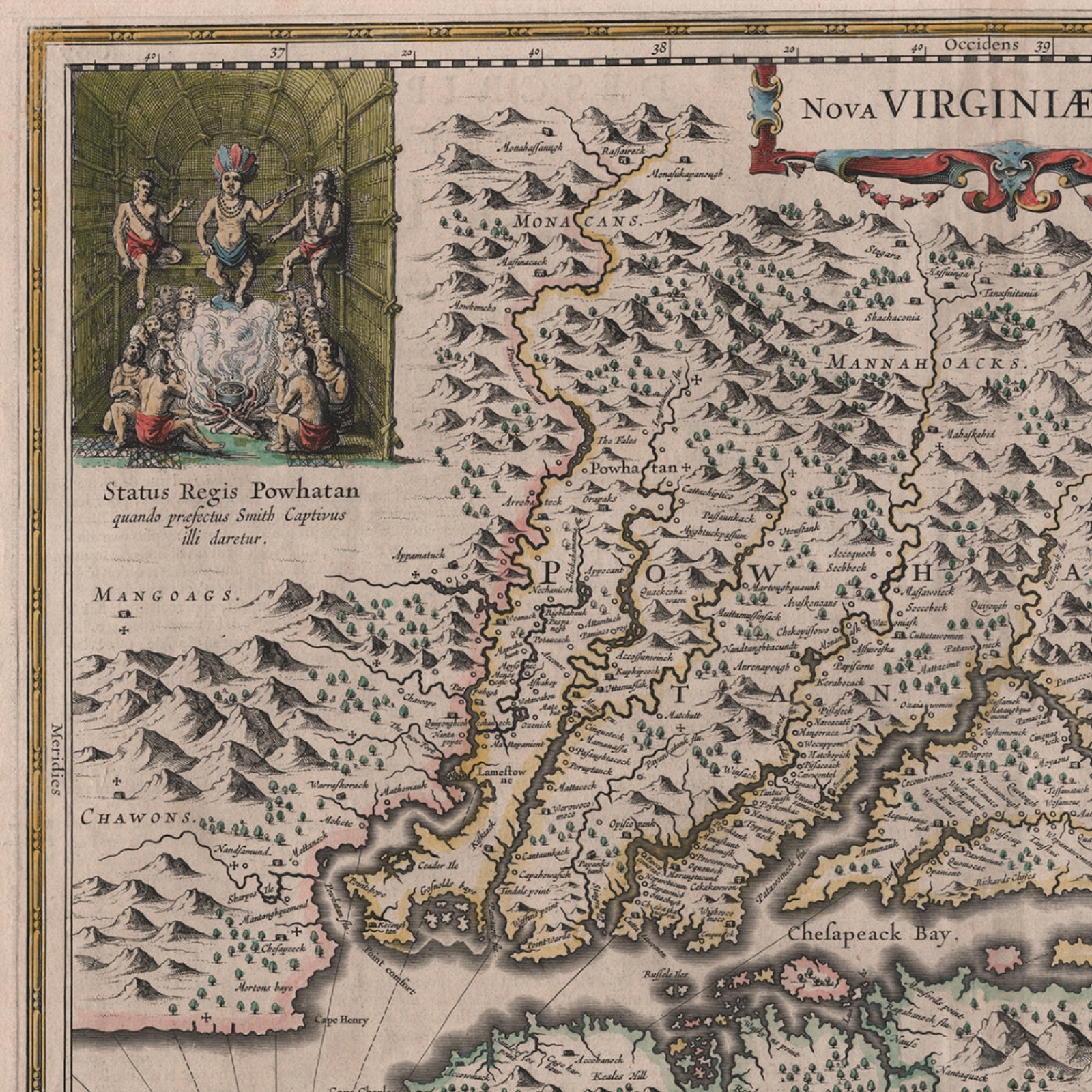
1630s Map of Virginia — Archival print — Nova Virginiae Tabula
1630s Map of Virginia — Archival print — Nova Virginiae Tabula
Couldn't load pickup availability

Updated May 15, 2025: We offered an original of this map from the 1630s tonight in our Rare Finds and it sold in less than 15 minutes. (See the listing here.) However, before we listed it we did a high-resolution scan so that we could offer an exceptional archival print that others could purchase and enjoy.
We also offer a very inexpensive reproduction of Smith's original map, but if you are looking for a very old map that shows some of the most important early European history of the Americas, you should definitely consider this map.
This is an advance order. We expect to ship this out in early June.
— Lee Wright | Founder
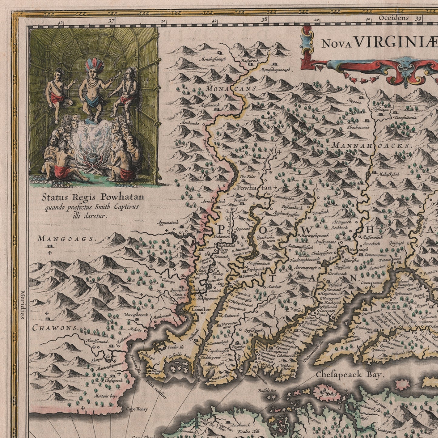
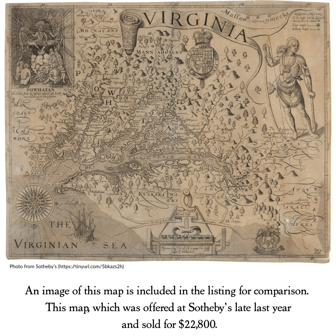
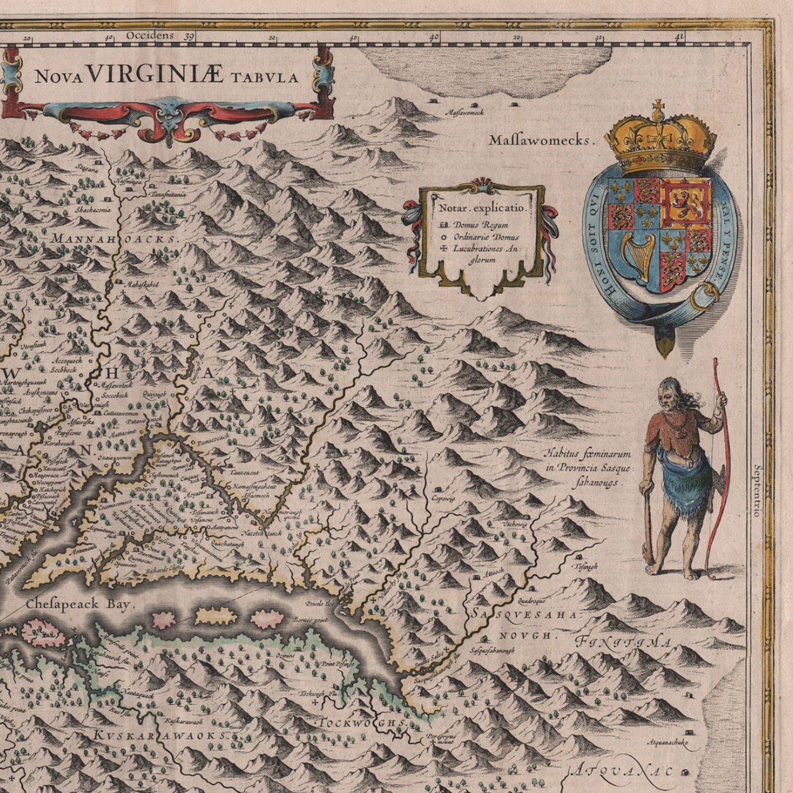
An archival copy of a beautiful, hand-colored map that is based on John Smith’s map of Jamestown, which was published in 1612 and which Philip D. Burden, in his definitive The Mapping of North America, calls, "One of the most important maps of America ever produced and certainly one of the greatest influence . . .” (We've included an image of Smith's map in the photos for comparison.)
"Nova Virginiae Tabula" translates to "New Map of Virginia" in French.
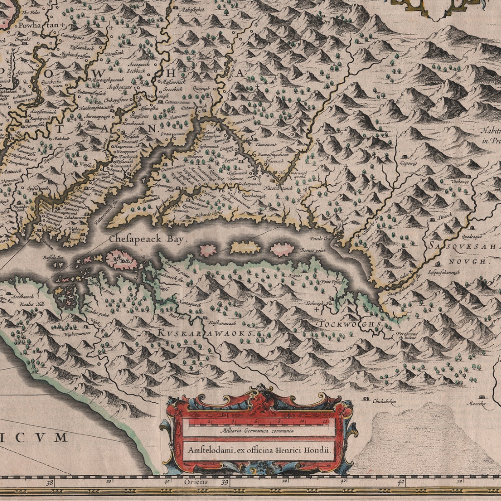
The map has the same inset as Smith's map of the Native American leader Powhatan at the upper left; a coat of arms and Native American figure and cartouche at the bottom.
As described in the historical background below, there is quite a history behind the printing of this map.
The original map we offered had lengthy text on the back describing the discovery and settlement of Virginia, the role of John Smith and other early leaders, and the significance of the James River and Jamestown in the colony’s founding.
An image of the back along with the entire text and its translation can be found in this post. You can download a PDF of that translated text here.
Image size: 19.75" x 15"
Paper size: 22.25" x 18.75"
Printed by a fine art printer here in the United States using archival inks and heavyweight cotton rag, acid-free archival paper (230 gsm).
Historical background
From Wikipedia:
"A very fine example of Henricus Hondius’ 1630 map of the Virginia colony and the Chesapeake Bay. Oriented to the west, this map covers from Cape Henry to the Susquehanna River and inland as far as the Appalachian Mountains. The Chesapeake Bay is shown in full as are many of its river estuaries, though topographically this map places a number of mountain ranges where there are in fact none. Cartographically this map is based upon John Smith’s landmark map of the Virginia colony issued in 1612. Smith’s fine survey work, as well as reports from indigenous American Indian tribes, and fanciful wishful thinking, combine to make this one of the most interesting maps of America to emerge in the 17th century. Philip D. Burden, the author of The Mapping of America, considers this map, Nova Virginiae Tabula, to be one of the most important maps of America ever produced and certainly one of the greatest influence.
"To fully understand this map one must first realize that most Europeans believed the Pacific, or at least some great bay that led to the Pacific, lay just a few days travel inland. In the minds of most Europeans of the period, the trade potential for the Virginia colony was entirely dependent upon it being a practical access point to the riches of Asia. Thus the significance of large and mysterious body of water appearing in the land of the Massawomecks, in the upper right quadrant, becomes apparent. Of course, much of this land was entirely unexplored by the European settlers in Jamestown, shown here on the Powhatan River (James River), who relied heavily upon American Indian reports for much of their cartographic knowledge of the Virginia hinterlands.
"The Masawomecks themselves were a rival of the Powhatan and made their home near the headwaters of the Potomac. These, like many other indigenous groups of the region made only a brief and frequently violent appearance during the 17th century before entirely disappearing, mostly from disease and war, in the early 18th century. In the upper left quadrant there is an image of the American Indian chief of the Powhatan sitting enthroned before a great fire in his long house.
"One of the more popular legends regarding John Smith was is capture and trial before the chief of the Powahatan. Smith was convinced that his liberation had something to do with the youthful daughter of Chief Powahatan, Pocahontas, taking a liking to him. Though this grew into a fictious legend of its own, the truth is more likely that Powhatan saw Smith and his Englishmen as potential allies against the rival American Indian groups, such as the Massawomecks, that were pressing hard against his borders. There are a number of different editions of this map and its publication by various map houses in various states made it the first widely distributed map of the Virginia colony and of John Smith’s important map.
"There was, however, a scandal relating to its publication. The map was originally drawn and engraved in 1618 by Jodocus Hondius based upon the first edition of John Smith’s 1612 map. When Jodocus died in 1629, he and his brother, Henricus Hondius, while collaborating on the Hondius Atlas Major , had established and maintained separate business for some 10 years. Jodocus’ death enabled the competing cartographer, Willem Blaeu to acquire a large number of Jodocus’ map plates, which he promptly published in 1630 as the Atlantis Appendix . Henricus, in the meantime, had been counting on Jodocus’ new plates to enhance his own, by then outdated, Hondius Atlas Major . A surviving contract dated March 2, 1630 reveals that Henricus Hondius and his partner Joannes Janssonius hired engravers to produce a number of new map plates copying the work of Jodocus – now in the hands of the Blaeu firm. This map was among the most important on that list and accounts for the quantity of variants of this map issued by competing Blaeu and Hondius firms."
Additional background covering some of the same history, from a Belgium map dealer:
"This is Henricus Hondius' derivative of John Smith's crucial map of Virginia, 1612. It is, however, drawn from his deceased brother Jodocus' version of 1618. The two have led separate careers for at least ten years, and in 1629, upon the death of Jodocus, Willem Blaeu acquired several plates from the estate. About thirty formed the nucleus of Blaeu's Atlantis Appendix of 1630. This challenge to the atlas of Henricus, which was by now quite dated, stimulated fierce competition between the two houses. The sale of plates must have occurred by 2 March 1630 as a contract of that date survives where Henricus Hondius and his partner Joannes Janssonius, angry at the sale of plates to their competitor, engaged engravers to cut some new plates after those of Jodocus within eighteen months so that they could advance their own atlas.
"The Virginia was one of the first engraved as it appears in Janssonius' Atlantis Appendix of 1630. Attractively engraved, it is the only Smith derivative to bear an Indian facing the Chesapeake Bay. After the death of Janssonius in 1664, the business was left to different parties. It could not be divided in such a way that ensured the continued production of the various atlases. In 1694 Petrus Schenk acquired all of the Atlas Major plates at public auction from the heirs of Jansson van Waesberge and began issuing the maps with his own imprint."
Source: Sanderus Maps
Shipping
Shipping
Free standard domestic shipping on orders of $75 or more
Just add items to your cart totaling $75 or more (before tax and after discounts), and the shipping fee will be removed. No discount code needed.
This applies to most items, including shirts, caps, sweatshirts, unframed prints and posters, bracelets, lapel pins, pendants, blankets, and other qualifying items.
For orders below $75
Flat-rate shipping: Regardless of the number of items you order, the shipping price for shirts, caps, unframed prints and posters, bracelets, lapel pins, pendants, and button packs is $5.95.
For hooded and crewneck sweatshirts, mugs, and blankets, the shipping cost is $8.95.
Our flat rate shipping means you can add two or more t-shirts, sweatshirts, or caps for no additional shipping charge.
Learn more about shipping here.
All original designs are copyrighted by The History List
All original designs are copyrighted by The History List
All designs are copyrighted by The History List and the History Nerd text and design on t-shirts is a registered trademark. If you see a knock off, please let me know.
Made by America
Made by America
Almost all of the new products we offer are designed by us and made in America and most of our Rare Finds were made in America.
Our original designs are based on our nation’s history and our love of American history. Read more about other things we've created, including The History List, History Camp, and The Pursuit of History, in addition to The History List Store.
All original designs are copyrighted by The History List.
Every product that is made in America states that in the product description and includes the "Made in U.S.A." graphic. There are a relatively small number of items where we’ve not been able to find a manufacturing partner here in the States, but we continue to look.
Our nation’s history—Our original designs